
Blog

Weekly xyHt News Links: 04/26/2019
TopoDOT announces its user conference for 2019 HxGN Content Program releases new U.S. aerial imagery of more than half the country Trimble Launches Mobile Augmented Reality Tool to Optimize Service by Connecting Remote Experts with Technicians in the Field Sky Power GmbH adds consulting and project development to portfolio Teledyne Imaging to showcase its advanced...

In the Blink of an AI
If we were to believe Steven Spielberg’s version of the future, curiously, robots can’t blink. It seems like mechas, as the life-like robots in his movie AI: Artificial Intelligence are called, lack the AI codes to involuntarily close and open their mechanical eyelids. Notice how almost all robots in Hollywood movies follow the same no-blinking pattern. Watch The Terminator movies, if you don’t...
Weekly xyHt News Links: 04/19/2019
Hemisphere GNSS Announces New Atlas®-Capable, Multi-GNSS Vector™ V200 GNSS Compass Quanta UAV, New INS/GNSS to Increase the Productivity of UAV-based Surveying Solutions Orbit GT releases 3D Mapping Cloud v19.4 supporting 3D Models and Hybrid Resources Parrot Unveils Thermal Imaging Drone: ANAFI Thermal True Terrain Following available for professional drone surveys and inspections Handheld, Mobile and...

Ocean Business 2019
With preliminary surveys already starting around the coast of the UK for another round of wind farms being built, the offshore industry descended on the National Oceanographic Centre in Southampton, UK for the bi-annual event, Ocean Business, centered around the offshore survey industry. Luckily, my home is a walk away from the event, so I was more than happy...

Geospatial World Forum 2019
At the GFW19, the geospatial industry, community, and professions find common ground to promote geo-business, to showcase innovation, and to collaborate to seek solutions for global issues. I’d like to emphasize the word “forum.” The Geospatial World Forum 2019 (GWF2019), held in April in Amsterdam, holds a special distinction and role in the global geospatial...
UAS + Lidar = “X-ray” Vision
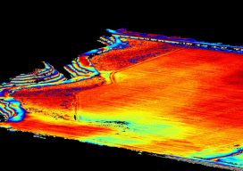
Image above: The same area as shown in the picture to the right with the ground extracted and the trees filtered out. A construction/survey project proves that UAS-borne lidar can penetrate tree cover to yield accurate ground data with improved post-processing times compared to photogrammetric solutions. I’m the VP of remote sensing at Morris P....
Advertisement