
Blog
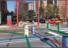
Hidden Infrastructure in 3D: Visualizing with AR
A visualization platform overlays data displays on your view of a job site by fusing data, AR software, and mobile-device sensors. From Superman’s x-ray vision, to current technologies that use radio waves to sense objects through walls. The ability, fictional or actual, to “see” through obstacles has long been a source of fascination. (Above: An...

Weekly xyHt News Links: 1/3/2020
FAA issues proposed rule on remote identification for drones
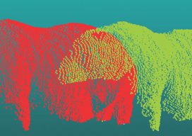
Trimble in the Wild: Scanning the Roundest Bear
Katmai National Park broke new ground in laser scanning this October when a survey-grade scanner was used for their annual “Fat Bear Week.” Traditionally, the fatness of many a Katmai Park brown bear has been voted on by awe-struck online onlookers—the park has several webcams—and has been a matter of personal opinion gauged by eye....

Positively Surveying: A 2020 Vision for Geospatial Professions
I’m imagining a world. It’s not a dream. It’s coming, and soon. One in which we bring data from the field and step into a virtual reality (VR) environment made by our data points that we uploaded to the cloud. Where we’re crafting and sharing our surveys in 3D and real-time, in collaboration with surveyors...

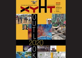
xyHt Magazine January 2020 Issue
Click on the cover below to view the January 2020 issue of xyHt magazine. Articles in the issue include (links will turn live throughout January): Nick Duggan and Nick Bearman on GIS Mentoring in the Age of Automation 4th Wave: What Is South? Riding High on AI: Artificial intelligence is making huge waves in the...
Outlook 2020’s 40 Under 40
The following is xyHt’s 2020 collection of 40 under 40: profiles of motivated and accomplished young professionals under 40 years of age. Click on each name to view their profiles below. Kwabena Obeng Asiam Researcher & Lecturer – Leibniz University Published PhD candidate in land administration; FIG Young Surveyors Ghana Evaluating the evidence and making...
Advertisement