
Blog

Build, Buy, Rent, or Hire?
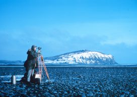
Seven years ago I was invited to attend a UAS flight course; this was an exciting proposition as the drone craze was not yet under way. In fact, the rules for operating drones in the U.S. were so in flux (as far as commercial and private drone use) that the course had to be held...
2019 Geospatial Summit
You Can’t Beat the Price of Admission As the march towards the new reference frame and datum rolls on approaching 2022, the National Geodetic Survey (NGS) continues to ramp up its outreach efforts to get us users prepared with the 2019 Geospatial Summit. They have hosted prior geospatial summits in 2010, 2015, and 2017, all...
Embrace the Mesh
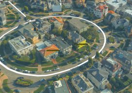
Above: A full 3D textured model of San Francisco produced through Skyline’s PhotoMesh 3D Reconstruction software and streamed for visualization and analytics in Skyline’s TerraExplorer. Surveyors and photogrammetrists capture reality data. But to model, manage, and provide access to massive and complex datasets—to provide your clients with true 3D mesh reality capture—you’re going to need...

The Bullet
Looking past an unfamiliar form factor reveals hidden strengths of a unique and capable high-precision GNSS field system. I’ll cut straight to the punchline: this little unit performed as well as many of the high-end (and pricier) GNSS rovers I’ve tried, both as a base-rover pair and as a network rover. And I had way...

xyHt Magazine May 2019 Issue
Click on the cover below to view the May 2019 issue of xyHt magazine. Articles in the issue include (links will turn live throughout May): Embrace the Mesh – Surveyors and photogrammetrists capture reality data. But to model, manage, and provide access to massive and complex datasets—to provide your clients with true 3D mesh reality capture—you’re...

Nighttime Imaging
An airport-mapping project indicates that a new set of applications may soon be served with airborne imagery collected under low-light and nighttime conditions. A geospatial services firm that specializes in building geographic information systems for airports (aka Airports GIS) faced a mapping challenge it had encountered before that’s common to airfields. Geopro Consultants, LLC, based...
Advertisement