
Blog

Weekly xyHt News Links: 09/20/2019
Topcon introduces new technology advancements in inspection and monitoring NCTech joins forces with GeoSLAM on ZEB Discovery Hemisphere GNSS Introduces Next-Generation R620 GNSS Receiver Teledyne Optech introduces its latest Airborne Laser Terrain Mapper for Wide Area and Corridor Surveying New Topcon technology offerings for BIM introduced at INTERGEO Hemisphere GNSS Announces Next-Generation S621 GNSS Survey...

Mapping an Historic Internment Camp
Above: By using drone technology to digitally preserve and reconstruct sites like the Amache Internment Camp, researchers, survivors, and the general public gain a better understanding of an important part of history. UAVs help scholars digitally preserve and reconstruct (in AR) the Amache Internment Camp in Colorado. As national landmarks age, documenting their structures to...

Mapbox cARTography
Over the last few months I’ve just had to get my hands dirty again with Mapbox. For those who don’t know what Mapbox is, let me introduce it. Mapbox is a platform for location-based data. It allows you to host your data with them so that you can stream it into your web maps, and...

My 2019 Interview with Jack Dangermond
Above: Dangermond and Duggan at the Esri UC 2019. What’s changed in a year? Editor’s Note: At last year’s Esri User Conference, writer Nick Duggan interviewed Jack Dangermond, co-founder (with Laura Dangermond) of Esri. At this year’s UC Nick spent time with Jack again to delve deeper. Nicholas Duggan: First, I need to thank you....
Weekly xyHt News Links: 09/13/2019
Teledyne Optech announces the CL-360, a compact, long-range, survey-grade lidar sensor for UAV and…. 100+ Presenters and Panelists on Roster for Commercial UAV Expo Americas October 28-30, 2019 in Las Vegas Septentrio introduces a new GNSS/INS system in a rugged housing Select and download sections of large point clouds right in your browser with NavVis...
The Science of Where to Build Anything
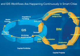
Above: Both Esri and Autodesk have shown this graphic at their individual presentations. Will the Esri/Autodesk partnership take BIM head-on? In August 2018, xyHt editor Gavin Schrock sat down with Jack Dangermond and Andrew Anagnost, of Esri and Autodesk respectively. They spoke of the natural industry links between the two companies and how they were...
Advertisement