
Blog
Nattaporn Thoonsaengngam
Research Assistant & Geodesist, National Astronomical Research Institute of Thailand Chiang Mai Province, Thailand “I wonder, because it is a wonder,” says Nattaporn Thoonsaengngam, a talented researcher, published geodesist, and professional photographer. The worlds of astronomy, geodesy, radio astronomy, humanity, and natural and built environments are all captured by her mind’s eye, photographer’s lens, and...

Weekly xyHt News Links: 01/25/2019
LiDAR and drones: learning to use the powerful combo Virtual Surveyor 6.2 Now Processes Larger Drone Survey Projects Exact Metrology Preserves History with Scanned Replica of Statue Topcon announces upgrade to MAGNET Collage Web complete with new deliverable options International LiDAR Mapping Forum January 28 – 30, 2019 Topcon announces advanced concrete application workflows Unique...
Yan Fu, PhD
Principal Research Engineer, Autodesk – California, USA 3D, 3D modeling, 3D reality capture, 3D smart cities—these seem to be the zeitgeist of the present world of AEC and are touted as the path forward that will reap great benefits in engineering efficiencies. Managing and using enormous spatial datasets is a challenge, as anyone who has...
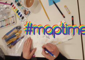
Maptime – Grassroots Geo-learning
From beginners to experts: #maptime chapters worldwide provide opportunities for cartographers, mappers, geospatial practitioners—and anyone with an interest in maps—to learn from each other. The concept and impetus behind #maptime are very simple: people who create (or have an affinity for) maps and mapping getting together to share common interests, tips, tricks, and techniques. If...
Niels Balens
Surveyor, BAM Contractors – Antwerp, Belgium We first learned about Niels Balens through last year’s Outlook nominations, and in researching him as a last-minute finalist we discovered his surveying project for a new tram line in the City of Antwerp. His work was so interesting that we developed it into the feature story, “A New...
Nick Bearman, PhD
GIS Educator, Geospatial Training Solutions & University College London – London, UK Nick Bearman is a gifted educator, with an extra bonus for the geospatial community in the UK (and increasingly worldwide) of a specialty in GIS. Bearman operates his own consultancy, creating custom training in GIS—both commercial and open source. He is also a...
Advertisement