
Blog

xyHt Weekly News Links: 10/20/17
NavVis partners with PrecisionPoint to bring the American indoors online DJI Unveils Technology To Identify And Track Airborne Drones Cloud migration path for Cadcorp web mapping Bentley Systems Announces Winners of 2017 Be Inspired Awards Virtual Surveyor Unveils Productivity Tools in Drone Image Analysis Software at Commercial UAV Expo EngineerSupply announces partnership with T&T Tools...
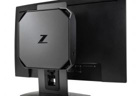
The Surprising HP Z2
A CAD designer reviews the HP Z2 workstation Editor’s note: Unless you’re looking in specific computer trade publications, you might not run across reviews of new PCs or workstations. The halcyon days of PC development in past decades and the battles for “bigger and more powerful” have given way to steady (but relentless) improvements. So,...
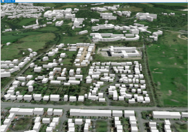
Making Heightmaps
There is no hiding it: I’ve been building a lot of 3D data recently, partly to sell, partly to fuel my adventures into augmented reality (if you’re interested in me adding this to the blog, please say!). The main vital thing has been the heightmap. Providing Certainty in 3D Heights What is a heightmap, you...

Congrats Intergeo Subscriber Winners!
Two Subscribers Won “Door Prizes” at xyHt’s booth at Intergeo in Berlin, 2017 Congratulations to new subscriber Linus Smid, a recent masters graduate in geotechnology (geochemistry and geoinformatics) from TU Berlin. Linus subscribed to the digital edition of xyHt at our booth and won from a random drawing an Oculus Rift package. We wish Linus...

Equipment Theft
We’re battling surveying and mapping equipment theft in South Florida and we need your help. Data collection is the foundation from which maps are made, and a majority of this data has its origins in the field. Unfortunately, criminals repeatedly target the equipment used by surveyors and mappers due to the instruments’ value and relative...
xyHt Weekly News Links: 10/13/17
MDA Completes Acquisition of DigitalGlobe, Creates Industry Leader in Satellite Systems, Earth Imagery, Geospatial Solutions and Analytics Bentley Systems and Topcon collaborate for Constructioneering Academy initiative Going Digital: Bentley Announces iModel 2.0 Cloud Platform and Its iModelHub Cloud Service – Automating Change Synchronization, Digital Alignment, and Immersive Visibility Flirtey Partners with Pioneering Ambulance Service to...
Advertisement