
Blog
3D, GIS, VR… We’re in Cloud City
When the father of GIS, the late Roger Tomlinson, first imagined a computerized system for handling land inventory mapping more than half a century ago, did he imagine that GIS would become such an integral part of our lives? At a click of a button, we can access directions to where we want to go,...
Do Your Work Right (and You Can Be ‘Smart’ Too)
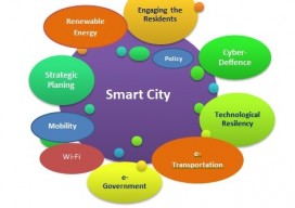
Ever since I saw the phrase “smart city,” I have cringed. Not because of the term but because of what it alludes to. To me it says that we (geospatial experts) haven’t done our work right. Let me explain. From Wikipedia: “A smart city is an urban development vision to integrate multiple information and communication technology...
xyHt Magazine June 2016 Issue
Click here to view the June 2016 issue of xyHt magazine To receive your free digital subscription please visit www. xyht.com/subscribe.

xyHt News Links: 6/3/16
Are PhotoSat satellite surveys really more reliable than ground surveys? New receiver with SF3 signal improves accuracy and uptime for precise field operations Topcon announces increased integration with Autodesk scanning software New Unmanned Aerial Photogrammetric Mapping Solution Siteco Moves into UAV Market with Sky-Scanner

senseFly’s Andrea Halter: From Academia to the Market
Above: This eBee Ag is outfitted with the Sequoia multispectral sensor. An interview with senseFly’s Andrea Halter Andrea Halter is a co-founder of senseFly, a Parrot company based in Switzerland that develops and produces aerial imaging drones for professional applications. Halter oversees the company’s marketing and sales teams. She’s a qualified land surveyor and holds a...

GeoBusiness 2016 – London
Wow! Just, wow [ed. Translation to US-English “Wow!!”]. Last week I was at the UK Esri annual conference with 3000+ people crammed into the tight QEII conference centre. This still didn’t prepare me for GeoBusiness this year. It was the same venue as last year but somehow they’ve crammed in a few more stands, and...
Advertisement