
Blog
Crossing the Barrier
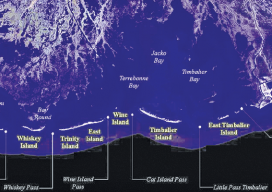
Above: The Barrier Islands off the Gulf Coast are threatened by coastal land loss. A Louisiana university overcame a barrier facing scientific research of coastal land loss—with a UAS. “We are losing an acre of coastline every 30 minutes,” says Dr. Gary LaFleur Jr., associate professor of biological sciences at Nicholls State University in Louisiana. And...
Using CartoDB
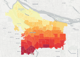
Above: This choropleth map of the distribution of street trees by neighborhood in Porland, Oregon, was created in CartoDB in eight minutes, using public data. From creating a map in eight minutes to creating market predictions based on streamlined analysis. Among the many mapping programs available, CartoDB stands out for its ease of use and sophistication....

xyHt News Links: 5/13/16
NovAtel launches 40-centimeter correction service, TerraStar-L Harxon releases rover radio for GNSS/RTK and precise positioning Teledyne Optech introduces low-cost, automated airborne surveying at GEOINT 2016 IMAGINiT Technologies Releases 2017 IMAGINiT Clarity Family of Products Insitu and PrecisionHawk form commercial drone alliance Monitoring Earth’s Magnetic Heartbeat

Primed for Growth
Aeryon epitomizes the current and coming uprising in UAS. The global UAS market (according to MarketsandMarkets) is set to grow at a 34.36% compound annual growth rate from 2015 to 2020, with UAS shipments to reach 3.8 million units in 2020. A new report from the FAA backs up this forecast, with a somewhat lower...

Survey Grade? Why Hiring a Licensed Surveyor is a Good Move
Only if you’re a Surveyor® Editor’s note: You can do plumbing without being a plumber, but not surgery without being a surgeon. Terms have meaning; surveying as a licensed profession is (but should not be) a term that is loosely applied. Surveyor and educator Kelly Ness offers the following thought-provoking look at the use and...
UAS: It’s Unstoppable and Headed Your Way
From time to time I like to stop and think about the mission of Pangaea and explain that mission to you. My task is exposing you to new, emerging geospatial technologies. But why bother? Here’s a little analogy I thought of to help explain why keeping abreast of new geospatial tech is critical. Imagine emerging...
Advertisement