
Blog
Fluid Data: GNSS and iPads
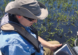
Lawrence Spencer puts the Trimble R1 GNSS receiver and iPad to work on the Kissimmee River. Pairing GNSS with iPads opens seamless data flows for a water management district in Florida facing wetlands complexity. Lawrence Spencer first joined the South Florida Water Management District’s (SFWMD) lake and river ecosystems section in 2006 as a...

Spatial Networking for Fun and Profit
Recently I attended a UAV event in my area (watch for the July issue of xyHt for more) that got me thinking about the role of networking in our profession. Not RTK, CORS, or even WANs or LANs, but person-to-person networking. Networking for fun. Meeting new people in the geospatial profession (and especially those interested...

Demystifying Mobile Mapping
Above: A mobile mapping rig of the engineering consulting firm Tetra Tech; the crew mapped the entire 288 miles of roadways in the city of Redmond, Washington in six days of driving. A surveyor examines (and asks users a lot of questions about) the Pegasus:Two system. Editor’s note: How could measurements taken from a moving vehicle...
UAS & The Combo that Opens Access
The most logical integration of technologies for surveyors is combining 3D laser scanning with UAVs. It’s no secret that many geospatial professionals are enamored with unmanned aerial systems (UAS). For many years, the pros and cons of deploying small UAS for mapping and surveying, along with their ongoing regulatory discussions, have been well researched and...

xyHt News Links: 6/10/16
Tallysman Expands its Geodetic Antenna Line CHC launches high-end GNSS receiver for science, surveying Establishing orthometric heights using GNSS — Part 7 Topcon announces global Agriculture Group SETTOP BATTERY II: Safety and high performance for your surveying instruments. FARO Releases High-Resolution 3D ScanArm for Reverse Engineering and CAD-Based Design Applications Topcon introduces new Professional Services team...

Mentoring: A Two Way Street
As the tools of our profession have changed, it seems that the opportunities for mentoring those following in our professional footsteps have diminished dramatically. Mentoring, or the lack thereof and what to do about it, may be the most widely discussed topic in our profession these days, from discussion forums, to professional associations, to the...
Advertisement