Category Archives: Lidar/Imaging
Geomatics at UAA
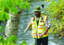
Above: Matt Santiago, current UAA geomatics student, is perfecting his surveying technique in the “classroom,” i.e. the South Fork of Chester Creek on UAA’s campus. The University of Alaska, Anchorage’s Geomatics Department continues to grow and place all its students in jobs at graduation. Matt Santiago arrived in Alaska wearing Air Force blue. When he...
Seen at Intergeo
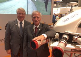
xyHt staff were out in force at the world’s largest geospatial conference in Frankfurt in October, and here’s what we saw of special interest. Riegl’s Big 4-0 Riegl celebrated its 40th anniversary at Intergeo. Pictured here are Jim Van Rens and Dr. Riegl, the company’s founder. New Vector Extraction in 3D Extraction of useful information...

Tracking Wildlife from the Sky
Above: Alan Wilson studied how cheetahs hunt with his modified aircraft. Credit: Stuart Dunn. To uncover the source of the cheetahs’ legendary hunting prowess, a researcher used a customized aerial camera to survey, film, and track their hunts. As recently profiled in a BBC documentary, Professor Alan Wilson, head of a research department at the...
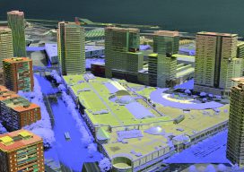
3D Cities from a Single System
Above: This screenshot is of CityMapper output. A look at the hybrid airborne system that combines lidar with oblique and nadir imagery. Over the last five years I’ve built and used a lot of 3D GIS and BIM models. Almost all of this has required the capture of stereo imagery and oblique imagery and a...
3D Straight Down
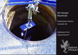
Seeing down manholes in detail is an innovation made possible with 3D scanning. [Above image: Deploying the camera system down a manhole to access the Hooksett, New Hampshire sewer system. No breaching of the hole happened, which is a serious OSHA consideration. (The GibbetMount shown here has a steel casing that’s since been upgraded to...

Surveyors Are Like Musicians
Don’t underestimate the value of talent. All 26+ years that I worked in the geospatial industry were with survey instrument manufacturers (Trimble and Leica Geosystems, plus start-up Cyra Technologies). But it was only in the most recent years of my time in the laser scanning segment that a major realization hit me about the full...