Category Archives: Lidar/Imaging
UAS + Lidar = “X-ray” Vision
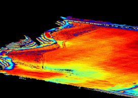
Image above: The same area as shown in the picture to the right with the ground extracted and the trees filtered out. A construction/survey project proves that UAS-borne lidar can penetrate tree cover to yield accurate ground data with improved post-processing times compared to photogrammetric solutions. I’m the VP of remote sensing at Morris P....
Point Clouds for Water Conservation
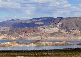
Image above: The Lake Mead region of Las Vegas, Nevada. A project to identify and quantify irrigated landscapes in Las Vegas demonstrates the advantages of using lidar to save precious natural resources. Persistent drought conditions in the western United States are dramatically reflected in the steady diminution, over the past 15 years, of Lake Mead,...
Mobile Mapping Evolves
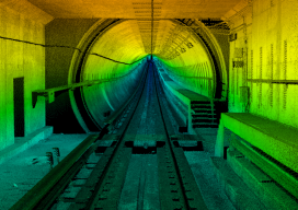
Image above: A colorized point cloud from a subway collect in Los Angeles, California. Credit: Joe Feyder, PLS, R.E.Y Engineers, INC., and John Jaramillo, Los Angeles County Metropolitan Transportation Authority. While lidar has been a standard geospatial tool for many years, the requirements of companies using it have been rapidly changing and evolving. Therefore, lidar...
ULS and the Search for Yamashita’s Gold
In the waning days of World War II, the Japanese were faced with a dilemma: what to do with the billions in loot taken from Southeast Asia. According to some accounts, faced with US naval dominance in the Pacific, the Japanese could not return the gold, gems, and other valuables to the homeland. Instead the...
Nullifying the Noise
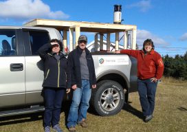
Image above: The Trifide crew of Ginette Allen and Hélène Gagné (with Herman Lavallée who rented them the truck) had to build a wooden rack and install it on the rented truck bed to provide a stable platform for the mobile mapping system. A female surveyor stays ahead of the competition and her critics by...

Why I Heart My Geospatial Job
Above: Marc wears a poncho given to him by his students in Paraguay. xyHt celebrates Valentine’s Day by sharing the love our contributors feel about their geospatial careers. Marc Delgado Loves His Students’ Reactions I love to see and hear my students’ initial reactions when they draw their first map from memory. I’m now in...