Category Archives: Surveying

Protecting Water Purity
Above: Croton Lake Gatehouse at the Old Croton Reservoir in Westchester County is the oldest part of the city’s current water system. At the reservoir’s construction in 1842, it had the capacity of delivering about 90 million gallons of water per day to the city. Surveying the NYC Watershed Where does the water you drink...
Inspired to Cross the Line
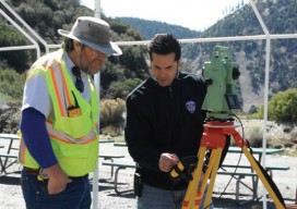
A former police officer hangs up his cuffs to make a greater impact supplying police departments with vital forensics equipment. Precision Survey Supply in Rancho Cucomonga, California, provides equipment to construction and survey companies as well as municipal agencies, but the customers nearest and dearest to the heart of company founder and owner Sam El-Said...
Geographic Education
A Holistic Approach, MOOCs, Formalized Teacher Training Geographic education is the pedagogical domain focusing on geographic literacy (“geolit”). Spatial literacy is related, and it tends to focus on forms of spatial information and technology, which in turn are related to the rubric of cognition and sometimes even areas like Human Computer Interaction (HCI) when one...
The (New) National Conference
Publisher’s Note: Two of our organizational partners, NSPS and MAPPS, announced the launch of a national geospatial conference this spring. We invited the incoming NSPS president to tell us what to expect and why we should all participate. Everything starts somewhere, or—in the case of a national surveying/geospatial conference—it must be reborn somewhere. So, why...
Exceeding the Limits
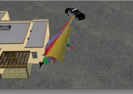
Forensic survey technology is now a need rather than a luxury as Latin America’s urban concentration accelerates. For decades the art and science of determining how a crime was commit-ted and how a car crash occurred has relied on expert hypotheses based on personal experience and memory. Experts have used tape measures, cameras, and paper...
Survey Web Tools
How to use them for land survey planning and reconnaissance. When I first used GNSS, it was my usual practice to go to the National Geodetic Survey (NGS) website to gather the data sheets for control monuments in the vicinity of my project area. I would plot these in a program called TopoScout, a topographic...