Category Archives: Surveying

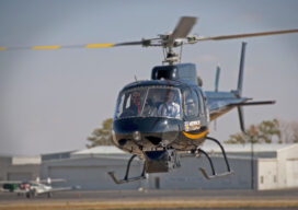
Located to Mobilize Anywhere in the Continental U.S.
Midwest Aerial Photography is growing to meet our customers’ needs. Celebrating 32 years in business this year, we are capable of deploying a highly-skilled airborne data collection crew equipped with industry leading digital acquisition technology to any location in the United States and much of Canada on short notice. We take pride in our ability to...
When a Drone Just Can’t Do It
There is a growing ebb in the tide of UAS adoption for aerial surveying, mapping, and remote sensing—finding the right balance between manned and unmanned aerial operations Unmanned aircraft systems (UAS), remotely piloted aircraft systems (RPAS), or just plain old “drones”—call them whatever you wish—have had a tremendous impact on geospatial industries. A decade ago,...

Legal Boundaries: The Ultimate Issue
What is the “Ultimate Issue Rule” in civil litigation? The Ultimate Issue Rule refers to Rule 704 of the Federal Rules of Evidence. The Federal Rules of Evidence (the Rules) were submitted to Congress by the Supreme Court in 1973, approved and enacted in 1975. They were intended to bring uniformity across all federal courts...
Surveying, Drones, and Danger
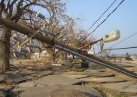
Experts say drones carry the promise of keeping the electrical grid safe amid increasingly intense storms The greater number and intensity of severe storms in the United States has communities rethinking their infrastructure. They’re making streets and parking lots permeable to absorb excess rainfall and rebuilding natural watershed features that help prevent floods. With the...
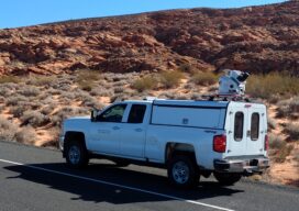
Lidar and Surveying: Infrastructure Relies on Surveys
Mobile lidar platform provides engineering firm with data sets for multiple deliverables In the past, project teams couldn’t get high-quality, actionable data quickly when performing surveys—there was always a trade-off between time and quality. However, advances in mobile lidar technology are significantly reducing the time it takes to collect data while still meeting strict accuracy...
Meet the Future of Mapping and Surveying at XPONENTIAL 2022
Innovation has never existed in a vacuum. Our world’s greatest technological advances are remembered not just for their scientific significance, but for the way they transformed the fabric of society itself. That’s why it’s critical that global leaders in uncrewed and autonomous technology collaborate on cutting-edge innovations that safely, securely, and reliably improve the human...