February 2019 Archives
Standalone UAV Lidar
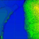
Above: The YellowScan Vx-20 collected this image in Hiroshima, Japan in May 2018. A surveying company developed a self-contained UAV lidar system so teams could gather data without a lidar specialist. Some companies are born (and some are transformed) when their founders switch their focus from using a tool for projects to developing that tool […]
Smart Access for 3D Cities
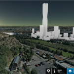
Above: A view from the OpenCities Planner online 3D city model web portal (hosted by Agency9) for Gothenburg, Sweden. A new skyscraper (now under construction) was added to provide planners and citizens a realistic idea of the visual impact of the proposed development. Credit for all images in this article: Bentley Systems. Today’s 3D city […]
Surveying Instruments on Mars

Above image credit: National Geographic Keen-eyed viewers of the groundbreaking National Geographic Channel series “Mars,” now in its second season, might have noticed familiar-looking equipment among the near-future science fiction gadgets—surveying instruments. We highly recommend this series for the techie and non-techie alike. It’s a mix of the story of a fictionalized first Mars colony, […]
Why I Heart My Geospatial Job

Above: Marc wears a poncho given to him by his students in Paraguay. xyHt celebrates Valentine’s Day by sharing the love our contributors feel about their geospatial careers. Marc Delgado Loves His Students’ Reactions I love to see and hear my students’ initial reactions when they draw their first map from memory. I’m now in […]
Aerial Self-sufficiency

Above: Universal Studios, Florida A large risk-assessment and data-analytics company created its own internal system to collect imagery, write software, and develop processing workflows. If a private company or public agency is large enough, it may be able to internalize all of the processes for its services rather than having to outsource any. For example, it might […]