GeoDude Archives
The GeoDude on the Adoption of Laser Scanning Today
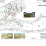
Part 2 Above: Although not yet fully mainstream for topographic surveys, laser scanning is frequently used to topo sites with a lot of detail and hardscape. Credit: Allegheny Surveys. With new and emerging technologies such as laser scanning, many professionals want to know “When is the right time to get in?” They may worry about […]
The GeoDude on Scanning Efficiency
A Snapshot from the GeoDude on Rich Data Here’s a comparison of today’s field and office efficiencies—for conventional surveying methods versus laser scanning—as applied to topographic and site surveys. Above: The firm that used scanning for this site survey noted that more than 60% of these types of projects entail scope creep; scanning typically avoids go-backs. […]
The Value of 360º Digital Panoramic Images
The GeoDude tells us that rich, new deliverables are changing client expectations for the better. One of the biggest impacts that 3D laser scanning has had on the market is a set of new client deliverables that it has spawned. One deliverable in particular (360° panoramic digital images) has profoundly raised the bar of client expectations, yet […]
UAVs and Laser Screening: Friends of Foes
Some professionals predicted doom for terrestrial scanning right when inexpensive drones with calibrated cameras hit the market and new image processing software wowed audiences with cool 3D mesh models of statues. But how have things actually turned out? I recently interviewed key industry users and vendors who are deep into both technologies – here’s what […]
Surveyors as Movie Makers
Above: Each virtual camera position needs to be properly oriented for what you want the viewer to see. Credit: Rodrigo Garcia. Opposite: The movie maker places several virtual camera positions to form a path for a fly-through effect on scan-based movies. Credit: Leica Geosystems. In my last Geodude article, I drew an analogy between surveyors […]
Navigating the World of Point Cloud Software

Here’s advice on how to understand various functions that point cloud software may need to perform, keys to look for in each, and sourcing options. When you’re working with laser scanning, choosing point cloud software can be challenging. Challenges For newbies, the challenge is determining the best software to start with. Your existing CAD or […]