May 2017 Archives
Peer Review: Professional Standards in the Surveyor’s Field
Let’s rethink how we license the land surveyor. By Daniel R. Muth, PLS, CFedS I had the benefit of starting my surveying career at a very early age. It began when my father, a licensed land surveyor, needed cheap labor. Being his son, I was readily available whenever and wherever […]
Robots for ExoMars: Drones and Space Exploration
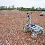
Drones are being used to test a space rover in familiar ways. By Martin Azkarate UAV manufacturer senseFly talked to Martin Azkarate of the European Space Agency about his work developing rover prototypes for planetary exploration, including how he employs a senseFly drone to test these cutting-edge robots. Martin is a space automation and robotics […]
UAS: From FUD to FOMO
By Jeff Salmon Welcome to our semi-annual UAS-focused issue. Looking back over the last six years of UAS development, I am struck by how far the technology has progressed. Right before our eyes a new industry has developed, one that promises to bring far-reaching changes to our profession and indeed to the whole world. And […]
“Next Big Thing” in Surveying Winners: Cyberpunk Dreams

When publisher Neil Sandler initiated the “Next Big Thing” essay contest in January, we were pleasantly surprised at the wide variety of entries. Because we hadn’t specified if the essays were to examine what the next big thing “will be,” “could be,” or “should be,” we got a mix of all three, from surveyors proposing what […]
GNSS Network SWIPOS Continues to Lead the Field(s)
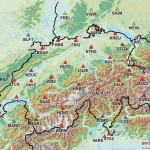
One of the oldest and most successful real-time GNSS networks continues to lead in providing precision and reliability for surveying, mapping, geodesy, science, and more. By Gavin Schrock, PLS In the early 2000s, when the first RTN were being introduced in North America, network developers would rely on the experience of their peers in Europe […]
Aerial Data Collection: Little Drone Takes on Big Airport
In a first-of-its-kind project, a UAS is tasked to collect aerial data of an international airport. By Jeff Salmon Normally when you add the words “drone” and “airport” to a sentence, it classifies as cringe-inducing. Just the opposite is true with this ground-breaking UAS project. The Hartsfield-Jackson Atlanta International Airport in Atlanta, Georgia, usually abbreviated […]