Outlook 2015 Archives
Big Data, Public Data
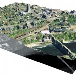
Above: A lidar-derived elevation raster DSM (of Dinkytown, MN) draped by an aerial photo. Free Aerial Lidar, Renewable Energy, an Infectious Mentality At the intersection of renewable energy, big data analysis, geospatial technology, and public data availability stands the Minnesota Solar Suitability Analysis project. Primarily manned by students in the University of Minnesota Master’s of Geographic […]
GNSS
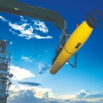
Above: The third satellite in IRNSS being tested before its successful launch. What Did Not Happen and Increases, Improvements, Innovations Sometimes the most telling precursors of the future are things that did not happen. By all accounts, 2014 should be remembered a horrible, terrible, very bad GNSS year with botched launches, toxic broadcast ephemerides, near peak […]
3D GIS
Breaking the Wall between Consumer and Professional, the Appearance of Disappearance, Versioning An Interview with Lawrie Jordon Contrary to what the current buzz might indicate, GIS and CAD have been 3D-rich from their start (although sometimes with elevation as an attribute, not necessarily part of the core spatial definition). Even in the 1990s era of […]
Transportation
Traffic Analysis in Real Time Until recently, geospatial experts have been unable to truly record traffic data because there hasn’t been a way to get a near-perfect record of traffic data at the lane level. Yet, it’s more evident now than ever that the need for near-perfect data is becoming a critical requirement for the […]
Hydrography

Above: Corporate social responsibility helps to ensure safety of the environment at a complex interactive drilling operation. Timely Delivery of Data and Products, Marine Spatial Planning, Increased Trusted Partner Resources Here’s a frameworkfor hydrography’s future. Start with the vision of a survey fleet, assisted by unmanned platforms, permanent seafloor installations, remote sensing, and trusted partner […]
Unmanned Systems
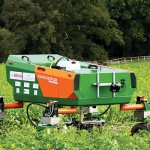
Above: This robot, the BoniRob, was developed for precision agriculture by Osnabrueck University of Applied Sciences in Germany, led by Arno Ruckelshausen. Robots for Precision Agriculture, Weather Forecasting, Scientific Studies From Amazon to Google to Domino’s Pizza, unmanned aircraft systems (UAS) have been drawing significant attention in recent months. Amazon plans to launch a Prime […]