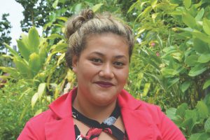
 Graduate Surveyor, Ministry of Lands Survey & Natural Resources
Nuku‘alofa, Tonga
In April of 2018, Tonga’s Prime Minister launched the world’s first regional strategy for surveying and geospatial capacity development. A regional consortium of Pacific maritime countries and territories including Tonga, Samoa, Vanatu, and many more face common challenges in geodetic issues; surveying, mapping, land rights and tenure issues; and issues relating to extreme weather events and changing environments. Tonga saw another first recently, with the first female surveyor for this island state. As reported by the journal Pacific Community, a scientific and technical organization, Malalo’s father was a surveyor, which would have certainly provided inspiration for his daughter to enter the profession. And her name, in an English translation, roughly equates to the term “geodesy.”
Malalo earned her bachelor’s in surveying with the Department of Surveying and Land Studies at the Papua New Guinea University of Technology, after which she began her work as a graduate surveyor for the Tongan ministry of lands and surveys. There are exciting and important surveying and geodesy initiatives underway in Tonga, like the installation of GNSS and tide gauge infrastructure to improve reference frameworks and monitor sea level rise; although early in her career, Siotasia is already contributing to these efforts.