Tag Archives: infrastructure
Integrating Location & Design: There must be a better way
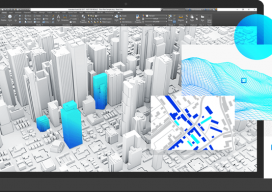
Autodesk & Esri Sponsored Content Engineers using building information modeling (BIM) software and geographic information systems (GIS) specialists constitute overlapping segments of the infrastructure project community. Sometimes, they work for the same company or public agency, but often they don’t: for example, the engineers might work for a design firm and the GIS specialists for...

Q&A with Trimble’s Ron Bisio
Bisio breaks down the as-a-service model, the rollout of the SX10, and smart infrastructure. We look for unfiltered insights from key folks in the geospatial industry, and the most recent INTERGEO exhibition and conference in Berlin was a prime opportunity to corner some of these folks for quick Q&As. One target was Ron Bisio, VP...

Infrastructure, BIM, and the Brothers Bentley
Infrastructure—the human footprint on the planet, the processes, systems, instrumentalities and built environment we inhabit—makes our lives possible. It provides the foundation for the lives we hope to live in the near and distant future. Modern infrastructure is the global tendrils of humanity, reaching all corners of the globe and binding us together in our...

Sputnik and Infrastructure
Today is the 60th anniversary of an event that both enlightened, and, in some ways, frightened the world. But it greatly inspired the worlds of science, engineering, and education. And it also sparked, arguably more than any other single event, developments for the geospatial professions and industries. On October 4th, 1957, a tiny polished metal...

Weekly Roundup: xyHt News Links: 3/31/17
Trimble Incorporates Galileo Support in New Version of its GNSS Infrastructure Management Software Sokkia introduces new GCX3 integrated receiver A new release of ‘Spatial Manager’ supports AutoCAD 2018 NOAA seeks new members for hydrographic advisory panel NSPS Student Competition Results NSPS Installs New Officers for 2017 Tallysman Introduces Dual Band + L-band services GNSS antenna...
Markets for Geospatial 2017: Part 2, Infrastructure
President Trump’s plan for investing in America’s infrastructure calls for $1 trillion in spending over the next ten years. The specifics of the plan are still a work-in-progress, but with largely bipartisan support, chances are that there will be a big push on infrastructure projects in the coming years, and that should translate into significant...