Tag Archives: xyHt

GNSS Innovation Keeps Utility Surveyors Safer
The ability to capture accurate points from a distance with images provides a significant leap in safety and efficiency for subsurface utility engineering.

Creating Earth’s Digital Twin
If airborne lidar can create an exact replica of Earth, will it help future geospatial professionals and scientists understand the history of our planet?

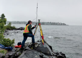
A Better GNSS?
With America, Russia, China, and the EU all now having GNSS constellations operating, what does it mean for surveyors and geospatial professionals?

xyHt Magazine Digital Edition: August 2021
xyHt's August issue features Global Navigation Satellite Systems and their impact on surveyors and geospatial professionals.

xyHt Weekly News Links: 07/30/2021
Trimble Boosts Flagship RTX Correction Services Performance Common Ground Alliance Releases Newest Edition of Best Practices Guide North Dakota DOT Selects GeoCue for UAS Program Esri to Expand Geospatial Innovation in St. Louis Area Commercial UAV Expo Exhibit Floor Nearly Sold Out dSPACE and Cepton Partner to Provide 3D Lidar Simulation infiniDome Debuts Anti Jamming...
Teaching the Future
A small university on Michigan’s Upper Peninsula is educating the next generation of surveyors and geospatial engineers