
Blog
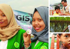
GIS Day
From the Coordinated Campus In a rapidly changing field such as geotechnologies, education is an ongoing concern and rightly so: if we are not lifelong learners, we won’t last long in this industry. But I contend that we as geospatial professionals also need to be aware of and provide leadership in larger geospatial education trends...
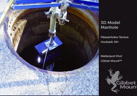
3D Straight Down
Seeing down manholes in detail is an innovation made possible with 3D scanning. [Above image: Deploying the camera system down a manhole to access the Hooksett, New Hampshire sewer system. No breaching of the hole happened, which is a serious OSHA consideration. (The GibbetMount shown here has a steel casing that’s since been upgraded to...
Interview with Esri’s John Nelson
A few years ago, John Nelson was relatively unknown in the public eye, but in the last year he has gained attention through work he’s been doing with Esri GIS software. Who would have thought you could recreate the Lord of the Rings maps or simulate paper or watercolors using Esri GIS? Theses are just...
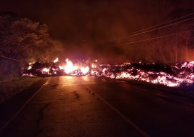
Lava Mapping
sUAS provide data for response to an unstoppable disaster. To most people living in Hawaii, it is not unusual to hear of an active lava event somewhere in the islands at any given time. Despite the nearly 70 earthquakes of magnitude 2.5 or stronger a week prior to the Kilauea lava event, it might have...
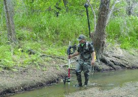
Street Views of the Water
Above: Martin Offenhauer surveys the Big Rock Road section of the San Diego River. Credit: SDRPF. Mapping rivers above and below the surface creates great opportunity for engineers and stewards. The way maps are produced and displayed varies greatly, depending on their extent, their intended use, and the peculiar challenges of each environment. Mapping a...

Weekly xyHt News Links: 11/02/2018
Microdrones News Release – Navmatica ME acquisition Airbus launches Ocean Finder to improve safety of assets at sea Teledyne e2v and partners to build a new generation of ultra-precise atomic clocks DJI Expands Drone Ecosystem with NewHardware, Software and Partnerships to Help Enterprises Gain Aerial Productivity
Advertisement