
Blog

Weekly xyHt News Links: 11/16/2018
CHC Navigation introduces the Alpha3D Mobile Mapping Solution Topcon speakers to hold construction validation classes at Autodesk University Fugro Delivers Actionable Intelligence to Construction Projects with New Gaia Insight Platform KIST: Enhancing Flight Duration Time of Drones with Lithium Metal Ion Batteries Multi-objective optimisation reaching new heights with latest scheduling software release LandMentor Empowers Users for...

Creating Album Covers with GIS—or Drawing Elevation as Vector Lines
In July 2014, a developer and neocartographer from Scotland created the “Joy Divionesque 3D Map.” This began a four-year onslaught of maps that replicate the style of the iconic Joy Division album cover, “Unknown Pleasures.” How does it work? Essentially the elevation is taken from an underlying terrain or digital surface map as points, which...

Anti-Anti-Drone Technology
Why we need it and what form it might take. I was walking down the UAS-tech-laden hall of the 2018 Commercial UAV Expo when I spied two booths touting anti-drone technology. I thought to myself, “My issue is the opposite—keeping my UAS in the air. I don’t need any help crashing it.” Yet, looking back,...

History – Art – Community (Updated)
A community gathers for the dedication of Dave LaMure Jr.’s sculpture, “A Vision of Tomorrow,” honoring pioneering surveyor John E. Hayes. Updated: Nov 11, 2018. Audio presentation added at the end of the article. “This has changed my life,” said Dave LaMure, Jr. “It has touched me here,” he added, gesturing to his heart. LaMure...
Weekly xyHt News Links: 11/09/2018
Seminar Programme at GEO Business 2019 – Call for Abstracts Announced SBG Systems offers GNSS+inertial navigation for surveying, UAVs Expanded GNSS and 5G: A gift for the surveyor Trimble announces new products at Dimensions conference Open Geospatial Consortium and Natural Resources Canada partner on Geospatial Innovation Trimble Unifies Business Center Software to Provide a Single Version...
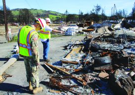
CA Wildfire Cleanup
The U.S. Army Corps of Engineers, under the direction of FEMA and in partnership with the California Governor’s Office of Emergency Services, removed more than one million tons of fire-related debris. Credit: Carol Vernon, Public Affairs, Pittsburgh District, USACE. The U.S. Army Corps helps rebuild lives with GIS technology. In October of 2017, numerous, fast-moving...
Advertisement