
Blog

Esri CityEngine: What Is It?
These past few weeks I’ve been trying to do some clever augmented reality stuff with Unity involving putting an object on the floor and ensuring it doesn’t wobble when you walk around it. (Yay for SLAM in mobile devices.) Although in software like Unreal and Unity you can download or buy models, what do you...
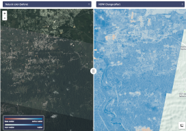
Radiant Earth
Connecting the global development community to Earth imagery and primary analytical tools. Nonprofits working on global development issues have had great difficulty acquiring and using a staple source of geospatial data in the form of Earth observation imagery collected by satellites. Anne Miglarese, the founder, and CEO of Radiant.Earth is working to change this. Miglarese...

Weekly xyHt News Links: 3/16/2018
Point Clouds from Smartphones Thales Alenia Space, Telespazio and Spaceflight Industries Finalize Alliance to Manufacture Smallsats at Scale and Deliver Innovative Geospatial Services Hemisphere GNSS Announces New Atlas®-Capable, Multi-GNSS Vector™ V123 & V133 Smart Antennas Geneq introduces SXblue Premier GNSS receiver Aerosense surveying drone markers use u-blox positioning Sir Wilson Harris obituary Mapping the electric grid...
Teaching Land Stewardship
The focus of the professional surveying societies today seems to be on the decline of the number of surveyors out there. Some are even beginning to raise this level of concern to that of soft panic. From the outside, the surveying community is headed for a perfect storm of obsolescence. Technology has contributed to the...

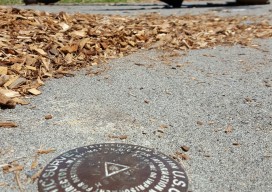
Alexa, Survey This Parcel
I’ve been thinking about the issue of automation and robots and their impact on the geospatial profession. I think it’s good news. So, let’s get started on dispelling the idea that “the ‘bots are coming for my job!” Here are two reasons why that’s not going to happen. 1) Everything I’m reading and observing argues...
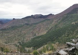
Surveying Boot Camp
Deep in the heart of Oregon’s Coastal Range, you can find an elite team of surveyors taking on some of the hardest terrain in the country. Oregon’s dense forests and steep mountain foothills are a challenge to traverse, but at Northstar Surveying, Inc., of Corvallis, it’s just part of the job. Under the stellar leadership...
Advertisement