
Blog

Aerial Imagery to the Rescue
Events in 2017 demonstrated without any doubts or reservations how vitally important georeferenced aerial imagery is in assessing damage and supporting relief efforts following a natural calamity. Last September, an impromptu consortium of companies in North America mobilized their forces and collected and analyzed mountains of data at near cost to help out in what...

Weekly xyHt News Links: 4/6/2018
Ouster Launches Two New LIDAR Sensors, Adopts NVIDIA DRIVE™ AI Platform Topcon introduces new laser series designed for distance and accuracy in construction projects What Drone Operators Need to Know About the Expansion of LAANC East View Geospatial Launches On-Demand Milspec Geospatial Data Topcon and Bentley to hold collaborative Constructioneering Academy in Brisbane senseFly and...

Professional Service or Commodity?
A Surveyor’s Thoughts on the QBS Process Editor’s Note: This month’s installment of Field Notes was submitted by James Nicolau IV, PLS, on the merits of using the quality-based selection (QBS) process to select surveyors for construction-staking services beyond where it is required under the Brooks Act (Public Law 95-582). When the QBS process is...
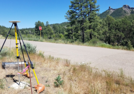
GEOID18: Make Your Mark and Improve Your Heights
As a community, we have the unique opportunity to contribute to the densification and improvement of our national geoid model and vertical transformation tools in support of the ongoing modernization of the National Spatial Reference System (NSRS). While the geoid model is a national level product, the impacts of this work are directly felt within...
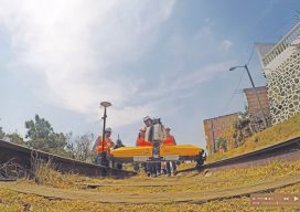
Mexico City’s Transportation Revolution
Using drones, lidar, and BIM, enterprising surveyors and geospatial engineers designed and constructed the city’s first high-speed train system. Editor’s Note: Lessons learned from a problematic rail project in Mexico City prompted an initiative to pull out all technological stops for a subsequent new rail line. An innovative, tech-savvy firm that had demonstrated its capabilities...

xyHt Magazine April 2018 Issue
Click on the cover below to view the April 2018 issue of xyHt magazine. Articles in the issue include (links will turn live throughout April): GEOID18 – Make your mark and improve your heights. BigSUR – A software team creates a large-scale, structured, urban reconstruction system that handles multiple data sources with deep learning. Law & Order – The...
Advertisement