
Blog
A Correctly Weighted Least Squares Adjustment, Part 3
Estimating Standard Errors in Angular Observations In the previous articles (January and February 2016) I discuss the unreliability of standard deviations when they are computed from a small sample of observations, as well as how to estimate errors in centering an instrument over a well-defined point and how to estimate the standard error for electronically...

xyHt News Links: 4/22/16
3D Robotics Announces Transformative New Software for the Solo Smart Drone Platform Topcon and RDO announce expansion to GNSS network service Trimble Announces Call for Speakers for its 2016 Dimensions User Conference Introduction of complete propulsion systems at Xponential 2016 Investigation launched over possible UAV/airplane collision Leica Geosystems launches smart antenna with superior performance DJI Unveils...

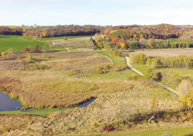
Reality Capture in 2016
An overview of criteria for obtaining and processing 3D data today. Above: Reality Capture has always played a role in the safety factor for surveyors and data collectors. Image courtesy of Olsson Associates. Ten years on, 3D and BIM are the de facto standards for design. It took firms a long time to recognize the...

Autodesk Launches AEC Excellence Awards
AEC Excellence Awards Expands Competition from Infrastructure to Embrace All of AEC Since 2012 Autodesk has sponsored the “Excellence in Infrastructure” competition, recognizing the world’s best examples of the application of BIM for infrastructure projects large and small. Based on the success of that effort, they’re pleased to announce the new AEC Excellence Awards, an expanded...
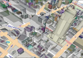
3D Cadastre
How to promote 3D land administration for a 3D world. We live in a 3D world, so shouldn’t we be basing decisions on 3D data? When people think about the word “cadastre,” they might envision a two-dimensional map of boundaries, but there is more to the concept of a cadastre than who owns what. There...
UAS Legislative Round-Up
What will 2016 mean for online commercial sUAS registration in the NAS? Online Registration Last year, registration for hobby/recreational sUAS went online. It was so simple I think it has confused people as to what the commercial registration process will look like. Because I have a recreational sUAS and am required to register it, I...
Advertisement