Category Archives: Spatial IT/GIS
What Can Spatial IT Do for You?
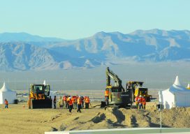
Helping firms meet the challenges of the global uptick in infrastructure development. Editor’s note: What is spatial IT? This umbrella term for the spatial component of the new wave of digital wizardry that’s transforming our geospatial and geomatics professions and industries can seem nebulous. xyHt has adopted the following working definition (as the term applies...
mESRIsoft
More than partners, Esri and Microsoft collaborate and combine platforms to benefit their users and the public. From their CEOs, Jack Dangermond and Satya Nadella, down to the individual developers and field sellers, Esri and Microsoft work together very closely. “We are connected at almost every level to each other’s companies,” says Lea Ann Thurman,...

My First Trip to the Esri UC
No matter what flavor of GIS you roll, there is no ignoring the annual Esri user conference in San Diego. The highlight is the opening plenary session which is always given by the (co) founder of Esri, none other than Jack Dangermond. To discuss this fully, we have to start at the beginning, which was...
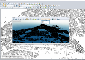
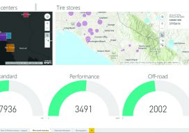
Global Mapper Review
Although I’ve been using GIS for more years than I can remember, until xyHt took me out to InterGeo I had never heard of Global Mapper. I thought I’d used every GIS there was; I’ve even used some that only a select few have ever heard of (StruMap anyone?). The market is saturated with GIS, and...
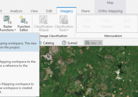
Using Ortho Imagery (Digital Aerial) in ArcGIS Pro
The new version of Esri’s ArcGIS Pro software offers the capability to use stereo imagery, something of great use to those looking to digitize and use 3D vector data. To this end, I thought I would try bringing in some stereo aerial data to see how the process works within ArcGIS Pro. Vague Knowledge At...

The Gamification of the Geospatial Industry
Why Is It Important? With huge, sprawling maps and realistic cities now appearing in our video games, it begs the question as to how these amazing cities render so quickly, yet we geospatial experts still sit waiting for 10 minutes for our software to open. For example, the notorious Grand Theft Auto: San Andreas (pictured...