Heights 2022 Archives
Blowing in a New Direction
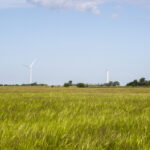
A new market is emerging for aerial mappers as investment in renewable energy grows Public and private utilities are focused on diversifying their energy portfolios after years of research and testing have improved the efficiency and reliability of alternative power generation methods. Support for the development of clean-energy options has never been stronger, creating an […]
When a Drone Just Can’t Do It

There is a growing ebb in the tide of UAS adoption for aerial surveying, mapping, and remote sensing—finding the right balance between manned and unmanned aerial operations Unmanned aircraft systems (UAS), remotely piloted aircraft systems (RPAS), or just plain old “drones”—call them whatever you wish—have had a tremendous impact on geospatial industries. A decade ago, […]
An Integrated Photogrammetry Solution
Carlson Software has innovated for the land development industry with software and hardware solutions built to work for the clients who depend on them every day. As a one-source solution, we provide CAD design software, field data collection, and laser measurement products for the surveying, civil engineering, GIS, and construction industries. Our flagship CAD program, […]
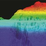
Mapping the Surface of the Ocean?
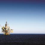
It is crucial that we keep accurate maps of the ocean’s shorelines, but when my company got a request to map the ocean’s surface 50 miles out in the Gulf of Mexico, my initial reaction was: Why? Isn’t the ocean just the ocean that far out? There aren’t any geographic features or elevation changes. It’s […]
From Nadir to Oblique
From Buzz to Shush Fighting the drone of drones Drones are hard workers. But because of the noise they make, many people are not fond of them. In a recent survey in Europe, when people were asked about their main concerns regarding the prospect of drone services in their cities, respondents from six countries chose […]
NOAA Advances Deep Channel Topobathy Lidar for Groundbreaking Alaska Project
Steep and rugged cliffs, rocky shores, changing turbidity, underwater hazards, and unpredictable weather are some of the extreme challenges of mapping the coastline and waters surrounding Alaska. However, a new topobathymetric lidar project for the National Oceanic and Atmospheric Administration (NOAA) conducted by NV5 Geospatial is leveraging a state-of-the-art combination of advanced remote sensing technologies […]