Tag Archives: lidar

BLK360 + ReCap Pro: Collaboration for Reality Capture
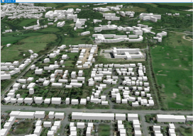
Autodesk and Leica Geosystems collaborate on a highly anticipated scanning solution, the BLK360: practical, high-precision reality capture for everyone. We see so much written about 3D, BIM, and virtual and augmented worlds; it is easy to wax poetically about the potential for spatial analysis, automated feature recognition, space planning, and 3D design. There is much to...
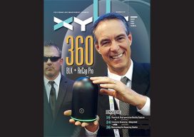
xyHt Magazine November 2017 Issue
Click on the cover below to view the November 2017 issue of xyHt magazine. Articles from this issue include (they appear as links as they go live throughout the month): BLK360 + ReCap Pro Protecting Your Eyesight Store-bought or Homegrown? Mentors for the Future Building a Solid Case: Forensic mapping with laser scanning Recovering...

Weekly xyHt News Links: 10/27/17
Septentrio launches the AsteRx-m2a and AsteRx-m2a UAS at Commercial UAV Expo WiBotic Announces a New Lightweight Onboard Charger Ideal for Wireless Charging of Smaller Drones Teledyne Oceanscience Introduces a new USV! Welcome to Z-Boat 1250! Solve Gas Detection Problems with Microdrones mdTector1000 CH4 Commercial UAV Expo and Drone World Expo Come Together in 2018 OGC...
Making Heightmaps
There is no hiding it: I’ve been building a lot of 3D data recently, partly to sell, partly to fuel my adventures into augmented reality (if you’re interested in me adding this to the blog, please say!). The main vital thing has been the heightmap. Providing Certainty in 3D Heights What is a heightmap, you...
xyHt Weekly News Links: 9/29/17
Teledyne Optech and IGI announce new cooperative agreement and first product offering Hemisphere GNSS Debuts Next-Generation S321+ and C321+ GNSS Smart Antennas Septentrio unveils the new Altus NR3 at InterGEO GeoSLAM Launching Enhanced SLAM Software and Next Generation Mobile Scanner at InterGEO 2017 INTERGEO 2017 Berlin: Geo-IT-event officially opened Applanix Announces POSPac Cloud for Mobile Mapping...
xyHt Weekly News Links: 9/22/17
Phase One Industrial Introduces 190MP Aerial System Orbit GT to showcase new v18 for Mobile, UAS, Indoor and Aerial Mapping at Intergeo, Berlin Hosting massive geodata made easier by new cloud solution LizardTech Awarded U.S. Patent for LiDAR Point Cloud Compression senseFly to launch industry-specific solutions at INTERGEO 2017 Measure’s First Drone Services Franchise Opens...