Heights 2018 Archives
Powerline Inspection
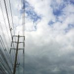
Drone? Ground? Helicopter? For years now drones, UAVs, UASs or whatever you wish to call them have been the revolution that promises to change the way we live. Five+ years into the drone revolution we are seeing some change—but it has certainly been a slower progression than expected. Linewise Aerial specializes in transmission line inspection […]
xyHt Magazine Heights 2018 Issue

Click on the cover below to view the Heights 2018 issue of xyHt magazine. Articles in the issue include (links will turn live throughout April): Powerline Inspection – Recommendations for those debating whether to complete their next project by drone, ground or helicopter. Aerial Imagery to the Rescue – Events in 2017 demonstrated without any […]
Assessing the Potential
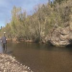
UAS-based Topobathymetric Lidar Surveys Understanding stream channel and floodplain morphology is critical for a number of efforts—from hydraulic modeling and stream-restoration design to aquatic habitat assessment. These applications require description of conditions both inside the channels and in the adjacent riparian zones. Gathering these data has typically relied on individuals on the ground or in […]
Huge Airport, One Vehicle
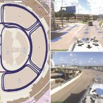
Inventory of roadway and airfield assets, including pavement surfaces, using the “One Vehicle” collection approach. Dallas Fort Worth International Airport (DFWIA) is the second-largest airport by land mass (27 square miles) in the United States and the third-busiest airport in the world by aircraft movement.It can easily be considered a city of its own. With […]
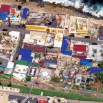
The 2017 Flooding of Missouri’s Meramec River
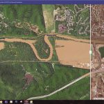
Missouri’s Meramec River is one of the largest free-flowing waterways in the state. With a source southwest of St. Louis, in Dent County, and the mouth at the Mississippi River in Arnold, some 20 miles south of St. Louis, its meandering 220 miles drain nearly 4,000 square miles in a watershed covering six Missouri counties. […]
Aerial Imagery to the Rescue
Events in 2017 demonstrated without any doubts or reservations how vitally important georeferenced aerial imagery is in assessing damage and supporting relief efforts following a natural calamity. Last September, an impromptu consortium of companies in North America mobilized their forces and collected and analyzed mountains of data at near cost to help out in what […]