Category Archives: Surveying

What is xyHt?
Stand in the place where you live Now face North Think about direction Wonder why you haven’t before “Stand” – R.E.M. Why an obscure geodetic expression? It’s not all that obscure—it represents a foundational element requisite to nearly all human endeavor. It touches your life explicitly and in the abstract. All of the ways that...
The Coordinate
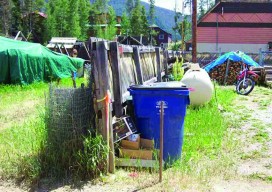
A steel fence post blended into the backyard, as if it were meant to be there for some purpose, like holding up firewood or stacking lumber. The surveyors—Igor “Eager” (The Kid) Kidinsky and Glenny “Glutton” (The Old Man) Dale—were looking for property pins along the alley, and neither one at first glance recognized this steel...

Canada’s New Vertical Datum: CGVD2013
Geodesy Editor’s Note: The study of Earth’s gravity field is one of the most important aspects of physical geodesy. While seldom mentioned in land surveying text books or discussed at local surveying, mapping, or GIS conferences, it is nonetheless one of the most important issues that geospatial experts deal with on a daily basis. Changing...
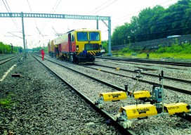
Setting a Standard in Railway Renewal
A highly traveled section of the UK’s West Coast Mainline rail corridor (between Warrington and Preston) required the renewal of three miles (five km) of track among four major junctions. In an intensive, nine-day continuous spell, the innovation team at Network Rail completed the work almost 16 months earlier than proposed—and avoided disrupting rail travel....

An Interview with Ken Jennings
An Interview with Ken Jennings: Speaker, Author, Geographer
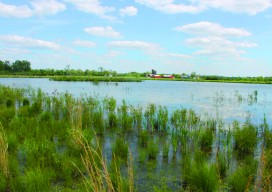
Wetlands Synergism
Professional interdependency is at the core of this project for acquiring federal conservation easements and restoring wetlands in Tennessee. Each item we touch these days has been shaped by a village of experts, from that cell phone in your pocket to the water coming out of the nearest drinking fountain. The surveying and engineering professions...