xyHt in print August 2015 Archives
Optical Monitoring
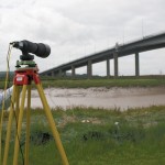
Above: Imetrum’s portable, long-range, camera-based monitoring system was used in the benchmarking trial. How reliable are optical monitoring techniques for civil engineering structures? Editor’s Note: Camera-based systems have long been used in industrial metrology for manufacturing, materials testing, and integrity monitoring. Now they’re finding utility in the “macro” realms of AEC (architecture, engineering, and construction). Many people in the […]
How FAA Exemptions Work for Commercial Operation of sUAS
How They Work for Commercial Operation of sUAS On February 15, 2015, the Federal Aviation Administration (FAA) published a Notice of Proposed Rulemaking, which proposes to enact part 107 of the Code of Federal Regulations. Specifically, the rulemaking proposes operating requirements to allow small unmanned aircraft systems (sUAS) to operate for non-hobby or non-recreational purposes. […]
Autodesk + Leica Geosystems

Two tech giants embark on a collaboration and education outreach. At June 2015’s HxGN LIVE (the annual user conference for Leica Geosystems and other divisions of Hexagon), we spied something rather surprising: an Autodesk booth. What’s more, someone at the booth was using Autodesk software for construction layout on a consumer tablet, driving a Leica […]
Quantum Navigation

Above: The Royal Navy submarine HMS Astute. Credit: LA(Phot) Paul Halliwell/MOD. Will freezing sub-atomic particles one day supplant GPS as the primary navigation technology? Many of the most accurate measurement devices, including atomic clocks, work by observing how atoms transfer between individual quantum states. The longer the atomic transition can be observed, the more precisely it […]
Epiphany on the Bow

Above: Shannon Hoy on the bow of the RVIB Nathaniel B. Palmer as she crossed through the Bransfield Strait in 2011. Photo by A. Margolin. A student’s journey from marine biologist to ocean mapper. Ever since I can remember I’ve wanted to work in ocean sciences. From when I was a child splashing in the tidal […]
Capturing More with Shallow-water Multibeam
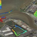
Interferometric sonars are providing a new tool for the hydrographic surveyor in shallow to medium-depth water applications. As we begin to return to normalcy after the deepest recession of most of our lifetimes, many ports, coastal authorities, and inland waterways are starting to look at infrastructure projects that have been kept on hold, and they […]