Tag Archives: GIS

Jack Dangermond Interview Part 1: The Company
At the Esri User Conference, xyHt European editor Nicholas Duggan sat down for a one-on-one interview with Jack Dangermond, Esri founder and CEO. In Duggan’s five-part online series, running each day this week, Dangermond discusses everything from Esri’s beginning to the future of GIS. Here in Part 1 the two discuss Dangermond’s company. Nicholas Duggan:...

Everything you ever wanted to know about Mobile Mapping
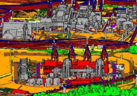
Explaining the tools and technology behind mobile mapping devices for experienced laser scanning professionals looking to make the jump to this new technology. In its short life, the market for 3D as-built documentation technology has seen considerable innovation. Among the myriad new tools to hit this market, nothing has changed the way we capture buildings...
GPI’s Advanced Geospatial Solutions for High-Altitude Mapping Projects
An established user of RIEGL airborne, mobile, and terrestrial sensors and systems, GPI Geospatial, Inc. (GPI) has added the VQ-1560 II to our toolbox of advanced digital sensors to further expand our capabilities.

Global Shipping Needs Geospatial Technology
Response to Covid-19 and its ripple effects on trade may be accelerating maritime industries’ adoption of geospatial technology Where global shipping is concerned, the Covid-19 pandemic is changing everything from navigation pathways, to crew and ship safety, to demand for commodities, and forcing the shipping industry to adapt, in part through new uses of geospatial...
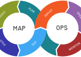
Let’s talk about MapOps
I’m not going to lie, I’m slowly mutating into one of those GIS high-level manager types who work less on real day to day map work and more about concepts and frameworks…even, at points strategizing. I hate it, give me some kriging interpolation or some hardcore viewshed analysis any day, but one thing is becoming...
Using QGIS in the Cloud with Amazon Web Services (AWS)
It’s easy to run a popular open-source geospatial suite on this hosted cloud platform: AWS. QGIS is a great piece of software, and I would really recommend you try it out if you are currently working with ArcGIS, MapInfo or any other piece of GIS software. However, if you don’t have admin rights on your...