
Blog

xyHt Magazine July 2018 Issue
Click on the cover below to view the July 2018 issue of xyHt magazine. Articles in the issue include (links will turn live throughout July): Precisely Shot: Aerial imaging, GIS, and GNSS play a crucial role in the success of golf’s 2018 U.S. Open championship. Recognition and Reasoning – How AI is going mainstream in the...
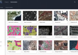
New EOS Platform Lets You Run Image Processing Tasks Online
Sponsored Content by EOS Data Analytics Most of your image analysis tasks that required ENVI or Erdas Imagine software are now available online thanks to EOS Platform. This new game-changing cloud service launched by EOS Data Analytics provides GIS professionals with a one-stop solution for search, analysis, storing, and visualization of large amounts of...

Weekly xyHt News Links: 06/29/2018
DJI Enterprise Joins InterDrone Exhibition Trimble’s New Tunnel Solutions Streamline Workflows for Survey and Engineering Professionals

NASA’s Awesome Long-endurance VTOL UAS
The wizards at NASA’s Langley Research Center took a look at the current state of UAS and found two big problems: The flight time and range of electric multicopters is too short, and many fixed-wing UAS require extensive ground support for launch and recovery. With these challenges in mind, the team came up with two...
Weekly xyHt News Links: 06/22/2018
Hexagon introduces the Leica BLK3D for real-time, in-picture 3D measurement Satellite Images Can Harm the Poorest Citizens Hexagon Launches Luciad V2018 Trimble Catalyst Now Supports GLONASS, Delivering Faster, More Accurate and Reliable Positioning Performance

Surveying Beyond the Water’s Edge
A remotely controlled unmanned survey vessel gives a land survey crew full hydrographic abilities for two busy marinas in Oregon. Founded in 2005, Statewide Land Surveying (SWLS) is a small business located in Gresham, Oregon, well acquainted with taking on challenging projects. While mostly engaged in land surveying, SWLS crew members have been involved for over...
Advertisement