
Blog

xyHt News Links: 04/14/17
MapChecker App by InfoGeographics NovAtel releases Oceanix Nearshore correction service for marine applications Indoor location, data see growth at MWC Trimble’s New Total Station Provides Millimeter Accuracy for Monitoring Applications Merrick Releases MARS® 2017 Software Suite
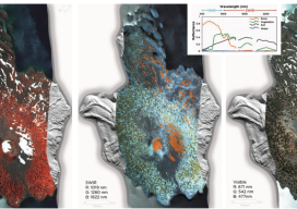
HSI on the Fly
One company details mapping applications of airborne hyperspectral imagery for agriculture, forestry, and resource mapping. By Patrick Burns and Scott Nowicki, PhD Remote sensing imagery has been collected with many different camera systems for many different applications over the past 50 years of the industry. Visible remote sensing imagery provides interpretable information available to most...
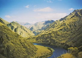
Re-imaging Hells Canyon
A geospatial company helps prepare for an environmental impact statement by scanning and orthorectifying historic imagery. Hells Canyon, North America’s deepest river gorge, encompasses a vast and remote region with dramatic changes in elevation, terrain, climate, and vegetation. Carved by the great Snake River, Hells Canyon plunges more than a mile below Oregon’s west rim...

Strategic Movement: Precise Monitoring in Practice
A Danish company builds a successful monitoring business by leveraging technology and expertise. By John Stenmark, LS Newton’s laws of motion tell us that nothing moves if it isn’t pushed or pulled. That concept is behind the success of LE34, a Copenhagen-based surveying company that has built a business strategy around structural monitoring for a...
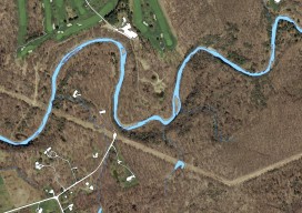
Mapping the Pennsylvania Lake Erie Watershed
Imagery was collected along 77 miles of shoreline to provide a better understanding of Pennsylvania’s natural resources. By Brian Stevens The Pennsylvania Lake Erie Watershed is a substantial part of the world’s largest surface freshwater system, the North American Great Lakes. The watershed is 512 square miles, consisting of 15 major sub-watersheds. It’s estimated that...
Weekly xyHt News Links: 4/7/17
Qinertia, a post-processing software to complete our offer for the surveying industry TCarta Marine to Introduce Gulf of Mexico Streaming Basemap Service and 2-Meter Bathymetric Data at Esri Petroleum Conference ClearEdge3D Releases VerityTM Construction Verification Software Tallysman introduces dual-band plus L-band GNSS antenna A look at NGS’ GPS on benchmarks program in Alaska Blue Marble Offers Free...
Advertisement