Heights 2015 Archives
Surrogate UAS

Above: Hart Drobish, president of Courtney Aviation, was a contractor to the forest service flying the air tactical control platforms on the Happy Camp Complex wildfire. Additionally, Drobish served as a ground liaison contact on the project, managing the flow of infrared and visual imagery from the aircraft to the end users. Combining UAV technology […]
SGM
Obtaining economical and accurate point clouds from semi-global matching. In the old days, mappers were thrilled with 30 meter USGS digital elevation models (DEMs). These were available for almost everywhere in the United States. Years later they started producing 10m DEMs, and life was really good. We had one elevation point “on the ground” every […]
Satellite Imagery’s Impact
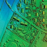
Above: The highest resolution of commercial satellite imagery is still more than an order of magnitude lower than the highest resolution attainable from aerial platforms. Keystone Aerial Surveys, Inc. developed this digital surface model from 1.75 cm digital imagery taken with a low-altitude flight. The resolution is sufficiently high to enable its use for mapping […]
Lidar for Forestry
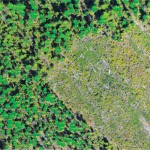
Above: Lidar-derived tree crowns and maximum tree-top heights are overlaid on a 20cm orthophoto. Vector-based products allow for a transition from the point cloud to GIS. A forester’s guide to understanding lidar topics, from upfront data-acquisition costs to business benefits to the path from research to operationalization. Although many lidar industry insiders never imagined the […]
UAS Coalitions
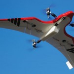
Above: Hybrid multirotors such as the FireFly 6 are offering solutions to common problems, allowing automated takeoff and landing along with waypoint flight control. Credit: Jon Barnes, Bajora Media. What are they doing for the UAS industry? Being an entrepreneur is a lot like being a surfer. You need a surfboard and access to […]
Working For You

Interviews with representatives from ASPRS, AUVSI, SPAR Point Group, MAPPS, and PAPA Several groups have evolved over the years to represent geospatial organizations that use aerial platforms in the course of their work. We asked five of these organizations (with a combined membership in the tens of thousands) the following questions: What do you do […]