
Blog
UAS Surveying without GCPs
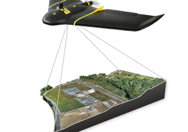
The subject of applying direct georeferencing to UAS platforms was a recurrent theme at the 2016 Commercial UAV Expo last week. Direct georeferencing offers the possibility of mapping without the use of ground control points, providing UAS operators a significant advantage in terms of speed. As an example of this technology, we reached out to...

Surveying Merit Badge
Surveying students jump into recruiting by hosting a surveying merit badge day. There are few challenges facing the profession of land surveying today that are as great as the need to revitalize our ranks with young and technologically savvy individuals. We all recognize the aging of our colleagues but cannot seem to identify the reasons...

xyHt News Links: 11/4/16
SmartBetterCities Released New Version of CloudCities Virtual Reality Tool Topcon announces distribution of the new Intel® Falcon 8+ System for North American markets Textron Systems Offers New Precision Survey Sensor on Aerosonde(TM) Small Unmanned Aircraft System Bentley Systems and Topcon join forces to advance cloud services for ‘constructioneering’ ESNC winner GUAPO a step ahead of...
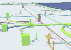
The Need for Civil BIM-level Objects
Alignment-based utilities are the key to BIM for civil engineering. It might sound odd to think that pipelines and conduit runs can play a key role in the evolution of BIM for civil engineering. In fact, you might wonder what I mean by “BIM for civil engineering.”BIM is a set of objects in a software...

November Editorial: Cue Team Building
For five days last week, I was dreading coming to work on Friday. It was the day most of my staff was excited about, but definitely not me. Let me backtrack. We at xyHt provide you, our readers, with lots of solid information about new technologies, skills, and ideas on operating your geospatial businesses. What...

xyHt Magazine November 2016 Issue
Click here to view the November 2016 issue of xyHt magazine.
Advertisement