
Blog

xyHt News Links: 3/3/17
Orbit GT and RIEGL strengthen data interoperability DJI Introduces M200 Series Drones Built For Enterprise Solutions Topcon announces enhanced integration of GT series total stations with Autodesk MDA to Acquire DigitalGlobe, Creating Industry Leader in End-to-End Space Systems, Earth Imagery and Geospatial Solutions Crane Camera Site Surveying: An Alternative to UAVs?

Workflow in Constructioneering
To remove workflow barriers among surveying, engineering, and construction, Topcon Positioning and Bentley Systems are teaming up. Compartmentalization in AEC workflows is a universal curse, with individual segments in design and construction often operating more like discrete enterprises than integral phases. All too often, legacy processes are plagued with a series of fits and starts....

xyHt and The First Four Ds of Construction
It is high time that xyHt gives a shout out to our new readers who have subscribed since our 2014 launch. We have gained thousands of readers in surveying, engineering, and the construction sector. This issue will be circulated broadly at CONEXPO-CON/AGG 2017, one of the largest trade conferences in the world and most definitely...
Caught Mobile Mapping
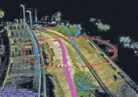
Above: Using a mobile mapping system, Construction CAD Solutions can generate high-accuracy point cloud data–in multiple views, as shown above and at left–to assist in its utility design function. Mobile mapping: A Chicago firm uses lidar innovation to survey for fiber infrastructure–for hundreds of miles. By Larry Trojak The ability to identify, accept, and then...
Surveying States: Different, Yet the Same
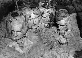
With the President’s Day holiday recently behind us, a day I refer to as Surveyor’s Day (think Mt. Rushmore) and National Surveyors Week starting on March 18, 2017, I can’t help but think about surveyors across the United States as a whole. Although my entire professional practice has been in California, over those years I have...
Deep-sea Mobile Mapping
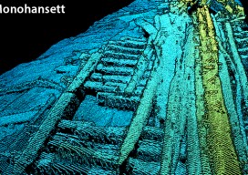
We’re all familiar with lidar-based mobile mapping from ground vehicles, and most of us are aware that aerial lidar is being used effectively to do shallow-water mapping along coastal and riverine projects. Deep-water lidar mobile mapping from an ROV? Well it’s a first for me. Most all of the subsurface surveys I’ve read about were...
Advertisement